INTRODUCTION
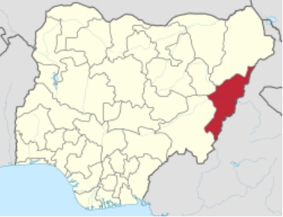
Adamawa State is one of the six states which make up the North-East geopolitical zone of Nigeria. It shares an international boundary with the Republic of Cameroon to the East and interstate borders with Borno State to the North, Gombe State to the North-West, and Taraba State to the West and South.
LANDMASS, LOCATION AND POPULATION
Adamawa State covers an area of 36,917 square kilometres. It lies at latitude 9°20′ North and 12°30′East. It has a population of 3,178,950 (2006 census), 4, 248, 436 (2016 forecast) and a population density of 81. The state accounts for 2.26% of Nigeria's total population.
HISTORY AND PEOPLE
The state’s name comes from Modibbo Adama, a Fulani disciple of Usman Dan Fodio and the founder of the Adamawa Emirate.
The emirate, which traces its origins back to 1809, is headquartered in Yola. The emirs are known by the traditional title of Baban-Lamido.
Adamawa State initially existed as part of the Northern Region in the three-region structure of 1954. It was then known as Adamawa Province.
In 1967, the military government of General Yakubu Gowon created twelve federal states and Adamawa became a part of the North-Eastern State.
With the creation of nineteen states in 1976 by the military government of General Murtala Muhammed, Adamawa became a part of Gongola State.
In 1991, the military government of General Ibrahim Babangida divided Gongola State into Adamawa and Taraba States.
The main ethnic groups in the state are the Fulani, Bwatiye, Chamba, Higgi, Mbula, Margi, Kilba, Ga'anda, Longuda, Kanakuru, Bille, Bura, Yandang, Yungur, Fali, Gude, Verre and Libo.
Islam and Christianity are the two major religions in the state although some of its inhabitants practice traditional religions.
MAIN TOWNS AND CITIES
Yola (capital city), Mubi, Ganye, Numan, Guyuk, Michika, Mayo-Belwa, Gombi, and Jimeta
LOCAL GOVERNMENT AREAS
ADMINISTRATORS AND GOVERNORS
Abubakar Salihu (Administrator – Military): August 1991 – January 1992
Abubakar Saleh Michika (Governor – Civilian (National Republican Convention)): January 1992 – November 1993
Gregory Agboneni (Administrator – Military): December 1993 – September 1994
Mustapha Ismail (Administrator – Military): September 1994 – August 1996
Joe Kalu-Igboama (Administrator – Military): August 1996 – August 1998
Ahmadu G. Hussaini (Administrator – Military): August 1998 – May 1999
Boni Haruna (Governor – Civilian (People’s Democratic Party)): May 1999 – May 2007
Murtala Nyako (Governor – Civilian (People’s Democratic Party)): May 2007 – February 2008
James Barka (Acting Governor): February 2008 – April 2008
Murtala Nyako (Governor – Civilian (People’s Democratic Party/All Progressive Congress)): April 2008 – July 2014
Ahmadu Umaru Fintiri (Acting Governor - Civilian (People’s Democratic Party)): July 2014 – October 2014
Bala James Ngilari (Governor – Civilian (People’s Democratic Party)): October 2014 – May 2015
Bindo Jibrilla (Governor – Civilian (All Progressive Congress)): May 2015 - May 2019.
Ahmadu Umaru Fintiri (Governor – Civilian (People’s Democratic Party)): May 2019 - Present.
ECONOMY AND EDUCATION
Adamawa’s vegetation is primarily savannah and its people are mostly farmers. Cotton, groundnuts, maize, yam, cassava, guinea corn, millet, and rice are all grown in the state. Village communities living on the banks of the state’s rivers engage in fishing, while its Fulani population rears cattle.
The most important mineral resource in Adamawa is Iron. Others include lead, zinc and limestone.
The major tertiary institutions in the state are ModibboAdama University of Technology in Yola, Adamawa State Polytechnic (also in Yola), Adamawa State University in Mubi, the American University of Nigeria, Yola, and Federal College of Education, Yola.
FAMOUS SITES AND CULTURE
Sites
Sukur Cultural Landscape, Madagali LGA
The Sukur Cultural Landscape was the first place in Nigeria to be declared a World Heritage Site by the United Nations Educational, Scientific and Cultural Organization (UNESCO).
The settlement dates back many centuries and is notable for its history of iron smelting technology, flourishing trade, and strong political institutions. Its paved tracks and terraced farmlands are unique to this part of the world. Its architecture is also remarkable, in particular the Palace of the Hidi (Chief), the centre of this culture's spiritual life.
Yadim Waterfall, Fufore LGA
Located in Yadim village, Fufore local government area of Adamawa State, the waterfall is one of the 16 tourists’ attractions recognised by the state government. It provides refreshing scenery for tourists and picnickers visiting the North-East state for leisure.
Koma Hills, Jada LGA
Koma is a primitive ethnic group in Northern Adamawa near Nigeria’s border with Cameroun.
The predominantly hilly settlements are often described by researchers as animal farms because of the presence of various species of animals in the location.
The settlements are under the control of clan heads or chiefs.
Gashaka Gumti National Park, Toungo LGA
Gashaka Gumti National Park is the largest park in Nigeria and covers 6,731 square kilometres. It is located in Toungo local government area of Adamawa State.
The park was created by the Federal Government in 1971and derived its name from two of the region's oldest and most historic settlements: Gashaka village in Taraba and Gumti village in Adamawa State.
The lush forests, rugged topography including mountains and plateau as well as rich assemblage of wildlife make Gashaka Gumti National Park one of the largest single protected areas in Africa.
Culture
Annually Adamawa plays host to 32 festivals. One of the unique cultural events in the state is the Phuki Festival. The festival signifies the celebration of the New Crops that are yet to be harvested among the people of Yandang.
Others include the three-day Zhita in Bazza as well as Dukwa and Yawal in Madagali local government area of the state.
The Zhita is an initiation festival among the people of the Higgi ethnic group in Bazza and takes place between August and September every year.
Dukwa is a three-day initiation of youths to adulthood among the Medugu people and is celebrated between July and August.
The people of the Marghi ethnic group celebrate Yawal to offer sacrifice to Mambul (spirits of the dead) and circumcision period. The three-day festival is marked yearly from the end of June to the first week in July.
There is also Sorro, a Fulani day-long observance commemorating the initiation of a group of boys into manhood. It is held in Yola every February.
NOTABLE INDIGENES
Ahmed Joda (1930-2021)
Ibrahim Mahmood Alfa (1942 -2000)
DID YOU KNOW
There are over 78 tribes and 58 languages in Adamawa State.
ADAMAWA STATE IN PICTURES

